Woodlands for Sale in Northern England
You are welcome to visit our woodlands with our sales details. For more information and all enquiries contact Liz & Dan Watson:
- Phone: 07970 116 515
- Email: lizanddan@forests.co.uk
Email updates
We send out an email update whenever we advertise a new woodland or forest for sale.

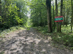
Sailhill Wood Almost 5 acres | £85,000 Freehold
A delightful secluded woodland, with a useful tool store, in an area of great natural beauty, overlooking heather moors.
Sailhill Wood is in an elevated position about 250 metres above…

Gillots Wood nearly 9 acres | £105,000 Freehold
Within easy reach of Durham, secluded and peaceful, Gillots Wood is a pine woodland with good access and great amenity value.
Gillots Wood is set in open, rolling countryside near…

Coates Wood Almost 3.5 acres | £102,000 Freehold
In a peaceful forest, Coates Wood is a small, mixed woodland with an attractive timber equipment store, on level ground with good access and a carpet of bluebells.
A sunny…

Glebeland Wood 5.75 acres | £89,435 Freehold
*** SOLD SUBJECT TO CONTRACT ***
An attractive woodland offering privacy, productivity and two distinct areas of character: mature planted conifers and well established, self seeded, mixed deciduous tree species.…

Park Wood over 4.5 acres | £70,000 Freehold
A tranquil and secluded mixed woodland with a varied age structure and an abundance of wildlife.
Access to the firm and stoney ride-stop entrance of Park Wood, is along the…

Swale Ings Wood Just over 3.5 acres | £75,000 Freehold
Swale Ings Wood is a private and tranquil pine wood, part of a larger forest with great access.
The wood is a planted ancient woodland site (PAWS),…

Hob Wood 5.5 acres | £84,500 Freehold
Hob Wood is a ‘planted ancient woodland site’ (paws) with much to interest the family Woodland owner. Tall slender pines cover two thirds of the area; they were planted about…

Garton Wood About 4.5 acres | £81,000 Freehold
A mixed woodland alongside a stream, part of a much larger forest and full of wildlife.
Surrounded on all sides by woodland, Garton Wood is located on a gentle slope…

Deighton Wood nearly 5.75 | £88,660 Freehold
A wood with a very well balanced mix of broadleaved trees and pines in a quiet yet easily accessible location, just south of York.
On arriving at the ride stop…

Plumtree Wood Almost 3.5 acres | £75,000 Freehold
A beautiful native woodland with a useful mix of deciduous and coniferous trees, rich in wildlife.
Plumtree Wood has large and mature pine, ash and oak trees with an understory…

Talbot Wood - Sold 3 Acres | £60,000 Freehold
A secluded woodland, tucked away from busy roads, a great place to escape and unwind.
A stone track leads from the tarmac farm road to the ride stop…
East Thistley Wood - Sold About 5.5 acres | £86,000 Freehold
*** SOLD SUBJECT TO CONTRACT ***
From the public highway a solid private track leads down to the entrance of East Thistley Wood. On entering the wood a slight rise…

Hawkmoth Wood - Sold 12.77 | £235,000 Freehold
Hawkmoth Wood is a beautiful mixed woodland, at the sunny southern edge of a larger forest, known as Brafferton Spring, there are swathes of bluebells and the wood sits beside…

Summerhouse Plantation and Amelia Wood - Sold Almost 16 acres | £192,000 Freehold
Once part of the historic Lawton Hall Estate, this beautiful ancient semi-natural woodland (ASNW) is surrounded by farmland, woodland and the old Lawton Hall park, complete with a lake.
The…
Can't find the right woodland for you?
- Subscribe to email updates to find out when we have new woodlands in this region.
- Find more woods for sale in Northern England on Woodands.co.uk.